import osmnx as ox

from cityseer.tools import io, plot![]()
OSM network from a relation id
Use an OSM relation id to create a networkx graph from OSM.
Use OpenStreetMap to identify a boundary relations id. Then, use osmnx to retrieve the relation id as a GeoDataFrame.
In this case, we’ll retrieve the London Soho boundary relation 17710512. For this, we can use the osmnx geocode_to_gdf function with the by_osmid parameter set to True. Note the preceding R prepended to the id as per the API documentation.
bounds_gdf = ox.geocode_to_gdf(
    "R17710512",  # OSM relation ID
    by_osmid=True,
)
bounds_gdf| geometry | bbox_west | bbox_south | bbox_east | bbox_north | place_id | osm_type | osm_id | lat | lon | class | type | place_rank | importance | addresstype | name | display_name | |
|---|---|---|---|---|---|---|---|---|---|---|---|---|---|---|---|---|---|
| 0 | POLYGON ((-0.14183 51.5151, -0.14162 51.51449,... | -0.141829 | 51.509966 | -0.129378 | 51.516365 | 258744666 | relation | 17710512 | 51.514065 | -0.135049 | place | suburb | 19 | 0.55752 | suburb | Soho | Soho, City of Westminster, Greater London, Eng... |
Convert the GeoDataFrame into a unified Polygon using the geopandas union_all method.
# returns a geoDataFrame - union for the geom
bounds_geom = bounds_gdf.union_all()
bounds_geom
If the geometry is complex, then the subsequent OSM API request (which happens behind the scenes) can fail due to a long URL request. In this case, you can take the geometrically simpler convex_hull instead. Alternatively, you can simplify the geometry, but remember to use spatial units matching the CRS of the geometry.
bounds_geom = bounds_geom.convex_hull
bounds_geom
The shapely geometry can then be passed to the cityseer osm_graph_from_poly function, as per other examples.
G = io.osm_graph_from_poly(bounds_geom)
print(G)
INFO:cityseer.tools.graphs:Generating interpolated edge geometries.
WARNING:cityseer.tools.util:The to_crs_code parameter 4326 is not a projected CRS
INFO:cityseer.tools.io:Converting networkX graph to CRS code 32630.
WARNING:cityseer.tools.util:The to_crs_code parameter 4326 is not a projected CRS
INFO:cityseer.tools.io:Processing node x, y coordinates.
INFO:cityseer.tools.io:Processing edge geom coordinates, if present.
INFO:cityseer.tools.graphs:Removing filler nodes.
INFO:cityseer.tools.util:Creating edges STR tree.
INFO:cityseer.tools.graphs:Removing filler nodes.
INFO:cityseer.tools.graphs:Removing dangling nodes.
INFO:cityseer.tools.graphs:Removing filler nodes.
INFO:cityseer.tools.util:Creating edges STR tree.
INFO:cityseer.tools.graphs:Splitting opposing edges.
INFO:cityseer.tools.graphs:Squashing opposing nodes
INFO:cityseer.tools.graphs:Merging parallel edges within buffer of 25.
INFO:cityseer.tools.util:Creating edges STR tree.
INFO:cityseer.tools.graphs:Splitting opposing edges.
INFO:cityseer.tools.graphs:Squashing opposing nodes
INFO:cityseer.tools.graphs:Merging parallel edges within buffer of 25.
INFO:cityseer.tools.util:Creating edges STR tree.
INFO:cityseer.tools.graphs:Splitting opposing edges.
INFO:cityseer.tools.graphs:Squashing opposing nodes
INFO:cityseer.tools.graphs:Merging parallel edges within buffer of 25.
INFO:cityseer.tools.util:Creating edges STR tree.
INFO:cityseer.tools.graphs:Splitting opposing edges.
INFO:cityseer.tools.graphs:Squashing opposing nodes
INFO:cityseer.tools.graphs:Merging parallel edges within buffer of 25.
INFO:cityseer.tools.util:Creating nodes STR tree
INFO:cityseer.tools.graphs:Consolidating nodes.
INFO:cityseer.tools.graphs:Merging parallel edges within buffer of 25.
INFO:cityseer.tools.graphs:Removing filler nodes.
INFO:cityseer.tools.util:Creating nodes STR tree
INFO:cityseer.tools.graphs:Consolidating nodes.
INFO:cityseer.tools.graphs:Merging parallel edges within buffer of 25.
INFO:cityseer.tools.graphs:Removing filler nodes.
INFO:cityseer.tools.util:Creating nodes STR tree
INFO:cityseer.tools.graphs:Consolidating nodes.
INFO:cityseer.tools.graphs:Merging parallel edges within buffer of 25.
INFO:cityseer.tools.graphs:Removing filler nodes.
INFO:cityseer.tools.util:Creating nodes STR tree
INFO:cityseer.tools.graphs:Consolidating nodes.
INFO:cityseer.tools.graphs:Merging parallel edges within buffer of 25.
INFO:cityseer.tools.graphs:Removing filler nodes.
INFO:cityseer.tools.util:Creating nodes STR tree
INFO:cityseer.tools.util:Creating edges STR tree.
INFO:cityseer.tools.graphs:Snapping gapped endings.
INFO:cityseer.tools.util:Creating edges STR tree.
INFO:cityseer.tools.graphs:Splitting opposing edges.
INFO:cityseer.tools.graphs:Merging parallel edges within buffer of 25.
INFO:cityseer.tools.graphs:Removing dangling nodes.
INFO:cityseer.tools.graphs:Removing filler nodes.
INFO:cityseer.tools.util:Creating edges STR tree.
INFO:cityseer.tools.graphs:Splitting opposing edges.
INFO:cityseer.tools.graphs:Squashing opposing nodes
INFO:cityseer.tools.graphs:Merging parallel edges within buffer of 25.
INFO:cityseer.tools.util:Creating nodes STR tree
INFO:cityseer.tools.graphs:Consolidating nodes.
INFO:cityseer.tools.graphs:Merging parallel edges within buffer of 25.
INFO:cityseer.tools.graphs:Removing filler nodes.
INFO:cityseer.tools.graphs:Merging parallel edges within buffer of 50.
INFO:cityseer.tools.graphs:Ironing edges.
INFO:cityseer.tools.graphs:Merging parallel edges within buffer of 1.
INFO:cityseer.tools.graphs:Removing dangling nodes.
INFO:cityseer.tools.graphs:Removing filler nodes.MultiGraph with 153 nodes and 224 edgesplot.plot_nx(G, plot_geoms=True)INFO:cityseer.tools.plot:Preparing graph nodes
INFO:cityseer.tools.plot:Preparing graph edges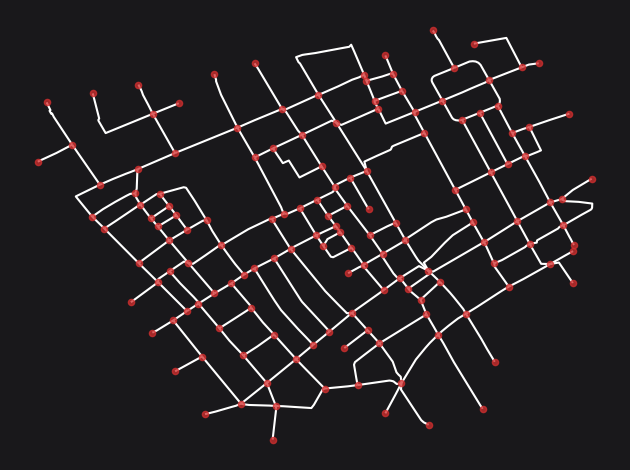
Conclusion
This notebook demonstrated how to retrieve an administrative or neighbourhood boundary from OpenStreetMap using an OSM relation ID via osmnx, and then use that boundary to create a cityseer-compatible street network graph. This approach is convenient when a well-defined boundary already exists in OSM, avoiding the need to supply a custom boundary file.
Next steps: To create a network from a custom streets dataset, see Streets Dataset.